


Introduction
Seismology is the scientific study of earthquakes and the propagation of seismic waves through the Earth. It is a branch of geophysics that investigates how energy released inside the Earth travels through rocks and how this energy affects the planet’s surface and internal structure.
Seismology plays a crucial role in understanding Earth’s interior, tectonic processes, and natural hazards. By studying seismic waves generated by earthquakes, volcanic eruptions, landslides, and artificial explosions, scientists can gain insights into the structure and composition of the Earth’s interior.
The study of earthquakes and seismic waves has developed significantly since the nineteenth century. One of the pioneers of modern seismology was John Milne, who developed early seismographs and established methods for studying earthquake waves.
Today, seismology is used not only to study earthquakes but also to explore underground resources, monitor nuclear tests, and understand the dynamics of the Earth’s crust and mantle.
Earthquakes
An earthquake is the sudden release of energy in the Earth’s crust that generates seismic waves. This energy release occurs when stresses within rocks exceed their strength, causing them to fracture or slip along faults.
Earthquakes are commonly associated with the movement of tectonic plates. The Earth’s crust is divided into large sections called tectonic plates, which constantly move relative to one another. When these plates interact, stress accumulates along faults. Eventually, the rocks break or slide, releasing energy in the form of seismic waves.
The point inside the Earth where an earthquake originates is called the focus or hypocenter. The point on the Earth’s surface directly above the focus is called the epicenter.
Earthquakes can vary greatly in magnitude and intensity, ranging from small tremors that are barely noticeable to massive events capable of causing widespread destruction.
Seismic Waves


When an earthquake occurs, energy is released in the form of seismic waves. These waves travel through the Earth and can be detected by instruments called seismographs.
Seismic waves are generally divided into two major categories:
- Body waves
- Surface waves
Body Waves
Body waves travel through the interior of the Earth.
Two types of body waves exist:
Primary Waves (P Waves)
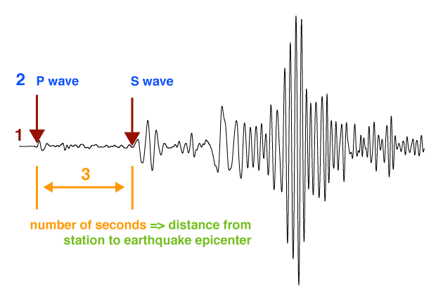
P waves are compressional waves in which particles move back and forth in the direction of wave propagation.
Characteristics:
- Fastest seismic waves
- Travel through solids, liquids, and gases
- First waves detected by seismographs
Secondary Waves (S Waves)
S waves are shear waves in which particles move perpendicular to the direction of wave travel.
Characteristics:
- Slower than P waves
- Travel only through solids
- Cannot travel through liquids
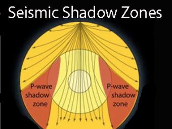
The absence of S waves in certain regions helps scientists infer the presence of liquid layers inside the Earth.
Surface Waves
Surface waves travel along the Earth’s surface and are generally responsible for most earthquake damage.
Two main types exist:
Love Waves
Cause horizontal ground movement.
Rayleigh Waves
Cause rolling motion similar to ocean waves.
Surface waves usually have larger amplitudes and longer durations than body waves.
Seismographs


A seismograph is an instrument used to detect and record seismic waves.
The device consists of:
- A suspended mass
- A recording system
- A frame attached to the ground
When seismic waves pass through the ground:
- The ground moves with the frame.
- The suspended mass remains relatively stationary.
- The relative motion is recorded as a seismogram.
Seismograms display the arrival times and amplitudes of seismic waves.
Scientists analyze these records to determine earthquake locations and magnitudes.
Measurement of Earthquakes
Earthquakes are measured using two main concepts:
- Magnitude
- Intensity
Magnitude
Magnitude measures the total energy released by an earthquake.
One commonly used scale is the Richter scale, developed by Charles Francis Richter.
The Richter scale is logarithmic, meaning each increase of one unit represents roughly ten times greater amplitude of seismic waves.
Another widely used scale is the moment magnitude scale, which provides more accurate measurements for large earthquakes.
Intensity
Intensity describes the effects of an earthquake at specific locations.
The Modified Mercalli Intensity Scale measures earthquake intensity based on observed damage and human perception.
Intensity varies depending on distance from the epicenter and local geological conditions.
Earth’s Internal Structure from Seismology


Seismology has played a key role in understanding the internal structure of the Earth.
By studying how seismic waves travel through the planet, scientists discovered that Earth consists of several layers.
Crust
The outermost layer of Earth.
It varies in thickness from about 5 km beneath oceans to about 70 km beneath continents.
Mantle
The mantle extends to a depth of about 2,900 km.
Seismic waves travel through this layer but change speed depending on rock properties.
Outer Core
The outer core is a liquid layer composed mainly of iron and nickel.
S waves cannot travel through this region, indicating that it is liquid.
Inner Core
The inner core is a solid sphere located at the center of the Earth.
Seismic waves traveling through this region help determine its composition.
Seismic Wave Reflection and Refraction
When seismic waves encounter boundaries between different materials inside the Earth, they may be:
- Reflected
- Refracted
These processes allow scientists to map the structure of Earth’s interior.
The study of these wave behaviors is similar to how light behaves when passing through different media.
Earthquake Distribution
Earthquakes are not evenly distributed across the Earth’s surface.
Most earthquakes occur along tectonic plate boundaries.
Major earthquake zones include:
- The Pacific Ring of Fire
- Mid-ocean ridges
- Transform fault zones
These regions experience frequent seismic activity due to plate interactions.
Earthquake Hazards
Earthquakes can produce several hazards.
Ground Shaking
The primary cause of structural damage.
Surface Rupture
Movement along faults can break the Earth’s surface.
Landslides
Earthquakes can trigger landslides in mountainous regions.
Tsunamis
Underwater earthquakes can generate large ocean waves.
These hazards can cause significant loss of life and property.
Earthquake Prediction and Monitoring
Predicting earthquakes with precise accuracy remains difficult.
However, scientists use several techniques to monitor seismic activity.
These include:
- Seismic networks
- GPS measurements
- Satellite observations
Early warning systems can detect seismic waves and provide warnings seconds before strong shaking begins.
Applications of Seismology
Seismology has many important applications beyond earthquake studies.
Oil and Gas Exploration
Seismic surveys help identify underground reservoirs.
Mining
Seismic techniques are used to locate mineral deposits.
Nuclear Test Monitoring
Seismology helps detect underground nuclear explosions.
Earth Structure Research
Seismic data provide insights into the composition and dynamics of Earth’s interior.
Seismology in Modern Science
Modern seismology uses advanced technologies such as:
- Digital seismometers
- Global seismic networks
- Computer modeling
These tools allow scientists to analyze seismic data with high precision.
Large international collaborations collect data from earthquakes worldwide to improve understanding of Earth processes.
Conclusion
Seismology is the scientific study of earthquakes and seismic waves that travel through the Earth. By analyzing seismic waves, scientists can determine the location, magnitude, and characteristics of earthquakes as well as gain valuable insights into the internal structure of the Earth.
Seismology has revealed the layered structure of the planet, including the crust, mantle, outer core, and inner core. It also plays an important role in understanding plate tectonics, earthquake hazards, and the dynamics of Earth’s interior.
In addition to earthquake research, seismology has practical applications in resource exploration, environmental monitoring, and nuclear test detection. As technology advances, seismologists continue to develop new methods for studying seismic phenomena and improving earthquake preparedness and safety.